see large image
)
Mesoscale Convective Systems (MCSs)
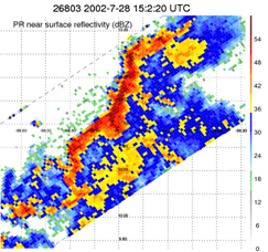
A mesoscale convective system (MCS) is a precipitation system that becomes organized on a distinctly larger spatial and temporal than its constituent convective clouds, and normally persists for several hours or more. MCSs may be round or linear in shape as the example shown, and include systems such as squall lines, Mesoscale Convective Complexes (MCCs), parts of monsoon depressions or tropical cyclones, among others, and a wide variety of midlatitude weather events. They have been noted across North America and Europe, with a maximum in frequency during the late afternoon and evening hours during the warm season (i.e. late spring and summer) on both continents, but often reach their maximum extent during the night. Over much of the world, MCSs bring about half the annual rainfall.
Here we define an MCS as a system with contiguous precipitating area greater than 2000 km ^2 from TRMM observations. During the past 14 years (1998-2011), there are about 1.2 million MCSs in the TRMM database. Information regarding these MCSs can be accessed through the search engine below.
|
Why there are invalid values in some parameters? There are many cases when TMI, VIRS or LIS do not return valid values due to the instrument calibration or some other reason. When that happens, we do not throw all the data away, because other instruments may be working OK. So we mark -999 for the corresponding parameters for these cases. |