Precipitation Measuring Missions (PMM)
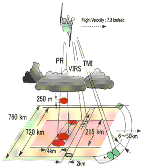
Precipitation Measuring Missions (PMM) including TRMM and GPM are NASA projects focusing on measuring the precipitation globally. The Tropical Rainfall Measuring Mission (TRMM, Kummerow et al., 1998) was launched in November 1997 with the data archieve dating from December 1997. On the TRMM satellite, the Precipitation Radar (PR) can provide detailed vertical distribution of radar refectivity, related to the number and especially the size of precipitation inside systems. The TRMM Microwave Imager (TMI) can provide information related to the vertically integrated ice and water path. The Visible and Infrared Scanner (VIRS) can provide information on cloud top temperature and reflectance. At the same time, the Lightning Imaging Sensor (LIS) estimates lightning flash rates. This webpage is dedicated to providing a searching tool of the past TRMM and future GPM observations and distributing some general scientifically ready products to the public from the Texas A&M University at Corpus Christi (TAMU-CC) precipitation feature database as an extension of NASA's GSFC PMM data service PPS.
Precipitation Features
One way to summarize the precipitation events from the TRMM dataset is to define Precipitation Features (PFs, Nesbitt et al., 2000). This method groups the pixels with near surface PR reflectivity greater or equal to 20 dBZ, or with an ice scattering signal defined by TMI 85 GHz Polarization Corrected Temperature (PCT, Spencer et al., 1989) less or equal to 250 K. Using this definition and the similar feature grouping concept, results have included validation of rainfall estimates (Nesbitt et al., 2004), the diurnal cycle of precipitation systems and their rainfall (Nesbitt and Zipser, 2003), the global distribution of storms with LIS-detected lightning (Cecil et al., 2005), deep convection reaching the tropical tropopause layer (Liu and Zipser, 2005), rainfall production and convective organization (Nesbitt et al. 2006), and the categorization of extreme thunderstorms by their intensity proxies (Zipser et al., 2006). In 2008, a set of new definitions of precipitation features and cloud features are introduced (Liu et al. 2008), expanding capabilities for analysis.